

Google DeepMind’s Agricultural Landscape Understanding (ALU) and Agricultural Monitoring & Event Detection (AMED) models are being used across 11 countries in Asia Pacific and Africa to strengthen agricultural sustainability, farmer access to credit, water management and policy decision-making.
Originally developed to support India’s agricultural ecosystem, the satellite-imagery-based AI models map field boundaries and monitor agricultural activity. Their outputs are now available to the wider ecosystem through APIs and Google Earth, with the ALU data layer emerging as one of the most popular layers on Google Earth globally.
The expansion comes as the global agrifood sector faces mounting food-security pressures. An estimated 2.1 billion people were food insecure in 2025, while global food production may need to increase by up to 50 per cent to support a projected population of 9.7 billion by 2050.
The models are being integrated into solutions aimed at addressing these challenges across multiple areas.
CarbonFarm is using the ALU API with Google’s Gemini to automate field-level insights, including field delineation, for programmes focused on reducing the environmental impact of rice cultivation. The initiative forms part of CarbonFarm’s goal of supporting 2 million hectares of low-carbon rice by 2030.
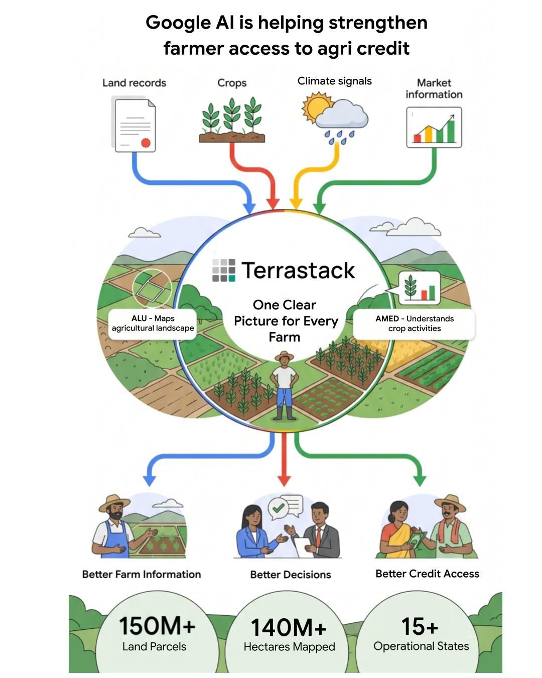
Terrastack has combined ALU and AMED APIs to develop a spatial intelligence platform that has mapped more than 140 million hectares of farmland. By reducing the need for physical field visits, the platform is intended to enable faster and more accurate decisions across India’s agricultural ecosystem, including those that can benefit farmers seeking credit.
In Telangana, the ADEX platform is leveraging ALU and AMED to support agricultural innovations aimed at the state’s more than 5 million farmers. One pilot, the Krishivaas application, uses the technology to generate hyperlocal advisories covering crop stress, crop-specific weather patterns and localised pest outbreaks.
The United Nations Food and Agriculture Organization’s (FAO) new geoAI4stats initiative plans to integrate ALU and AMED into its global CROPGRIDS data repository. Supported by Google.org through the AI Collaborative: Food Security, the initiative aims to strengthen agricultural monitoring and support sustainability-focused decision-making globally.
Karnataka’s Water Resources Department is combining ALU and AMED with localised weather and remote-sensing data to support dynamic water management across 2.6 million hectares of irrigated land in the state.
Commenting on the growing deployment of the models, Alok Talekar, Lead, Agriculture and Sustainability Research, Google DeepMind, who leads the AnthroKrishi team, said, “Our AnthroKrishi team has been dedicated to supporting targeted agricultural solutions that both increase farm productivity and reduce climate impact. The growing application of our India-first AI models’ APIs to impact-focused solutions – ranging from farmer credit to crop advisory and policy decision-making – across both the Indian and global ecosystem encourages us in our approach.”
“As these models expand to support even more countries, we look forward to the immense potential they will unlock for key global priorities, from food security to agricultural resilience,” he added.
With adoption expanding across geographies and use cases, Google and Google DeepMind’s AnthroKrishi team is focusing on making satellite-derived agricultural intelligence more accessible to organisations developing solutions for a productive, resilient and sustainable agricultural ecosystem.